Grantham flying sites
Note: This map only shows the position of Grantham town within the UK.
GRANTHAM see also ROPSLEY HEATH FARM
GRANTHAM see also STROXTON LODGE
GRANTHAM: Temporary aerodrome?
NOTES: GRANTHAM is listed as a venue for CD Barnard Air Tours in June 1931 but as it was common practise by these “Tours” or “Flying Circus” operators to often avoid using established aerodromes and therefore I think a separate listing might be justified here. Does anybody now know where they operated from?
GRANTHAM: Military aerodrome, see SPITTLEGATE below
SPITTLEGATE: Military aerodrome and also temporary civil aerodrome?
(Also known as SPITTLEGATE HILL?) (In WW2, known as RAF SPITTLEGATE)
Military users: WW1: RFC/RAF Training Squadron Station and Training Depot Station
29 Sqdn (SE.5As)
91 Sqdn (BE.2cs?)
1918 to 1939: RAF 100 Sqdn (Bristol F.2bs, DH.9As later Vickers Vimys. Then Fairey Fawns and ultimately Hawker Horsleys)
3 FTS, 12 FTS (Avro Tutors, DH Tiger Moths & North American Harvards)
In the early to mid 1930s the Armstrong Whitworth dual-control Atlas type was also employed here by the RAF for training
WW2: RAF Flying Training Command 21 Group
12 AFU (Bristol Blenheim & Airspeed Oxfords)
1536 BAT Flt (Airspeed Oxfords)
Gliding: 1970s only?
Civil users: Alan Cobham’s National Aviation Day tour in the 1930s?
Location: Near Saltersford, more or less on the modern Army Barracks site and N of the A52. W of Cold Harbour and about 2.5nm ESE of Grantham town centre
Period of operation: 1916 to 1920. It then seems the site lay fallow apart from some civil use until WW2. In and from 1985 used by the Army
Site area: WW1: 199 acres 1143 x 686
Runways: WW2: Steel matting for two runways 11/29 1061 grass 05/23 1189 grass
NE/SW 1372 grass
NOTES: Here once again, as I keep on banging on about in this 'Guide', why exactly did the RAF keep constantly moving squadrons around for such brief periods of time? Surely it seems to defy any rational understanding? Apart from the cost of moving all the support people and equipment, admin material etc, let alone the aircraft - it also takes pilots and aircrew time to become fully acquainted with the region they are flying across. With modern navigation methods and equipment this really isn’t a problem anymore for highly trained pilots and aircrew, both military and civil, but in the days when navigation was rudimentary at best getting to easily recognise local features was a huge asset. The history of 100 Sqdn is a good example. After a tour of duty at Baldonnel near Dublin they were moved to SPITALGATE in early 1922 - but only stayed three months it seems. In other words just when pilots and aircrews were getting to know their way around, they were moved on. Why?
A STAGING POST
During the Kings Cup Air Races in 1927 SPITTLEGATE (Grantham) was listed as being a ‘Staging Post’. If this pans out it would appear the change in name from SPITALGATE to SPITTLEGATE occurred between 1922 and 1927?
A FLYING CIRCUS VENUE
The 1932 itinerary from Alan Cobham’s National Aviation Day UK Display Tour gives Spittlegate Hill, Salterford, Grantham as the venue on the 14th June.
FINDING THE LOCATION
The map shown in the Willis and Hollis book for military aerodromes at the end of 1944 is very helpful in as much as the road layout of the A52, B6403 and B1176 seems to be pretty much the same today as it was then. This helps a lot to provide an exact position for SPITTLEGATE military aerodrome in late 1944. Tracing this aerodrome was quite a task at first but when John Ashby lent me the use of some Ordnance Survey ‘Aviation Maps’ published in 1930 GRANTHAM was clearly displayed. Oddly enough GRANTHAM is not listed in the Omnibus Edition of Military Airfields by Steve Willis and Barry Hollis, based on records pertaining to December 1944, instead it is listed as SPITTLEGATE.
In May 2014 I was pleased to discover a mention of RAF GRANTHAM by Stuart McKay in his excellent book Tiger Moth: “The first batch of military Tiger Moths was comprehensively air tested overhead Stag Lane in November 1931 much to the general satisfaction of the DH workforce, and the following day the aeroplanes were ferried to RAF Grantham. The pilots of No.24 (Communications) Squadron, normally based at Northolt, described the generous pre- departure hospitality as “typically DH” and welcome in view of the sub-zero temperature.” Knowing now of how things often were in those days, I suspect a tot or two of whisky (or similar) was provided?
HARVARDS AT GRANTHAM
I think it is also interesting that the first North American T.6 Harvards entered RAF service here in December 1938. Well before WW2 started and the outset of the now notorious ‘Lend-Lease’ agreement. A device some say, engineered by the USA to nigh on bankrupt the ‘British Empire’ and give the USA world dominance in industrial/financial terms. I expect there is an element of truth in this?
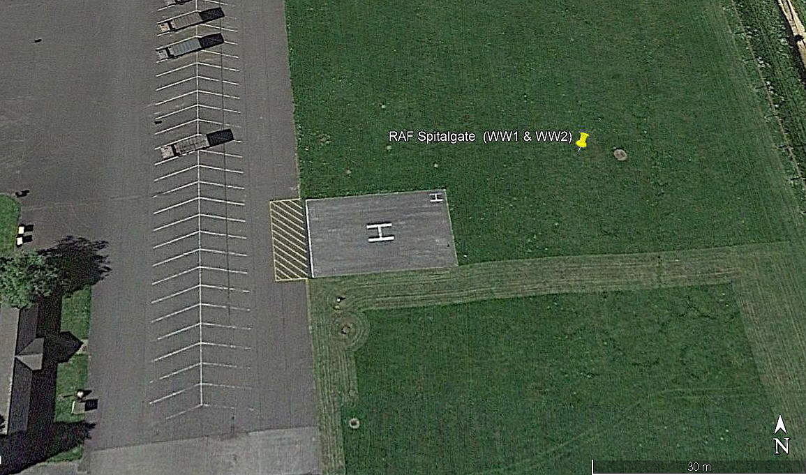
ARMY HELIPAD
Note: The first three pictures were obtained from Google Earth ©. The area view is from my Google Earth © derived database.
In 2021 Mr Graham Frost, a great friend of this 'Guide', pointed out the helipad. Presumably this was constructed after the Army took over?
We'd love to hear from you, so please scroll down to leave a comment!
Leave a comment ...
Copyright (c) UK Airfield Guide


