


Horham
HORHAM: Military aerodrome later private airstrip
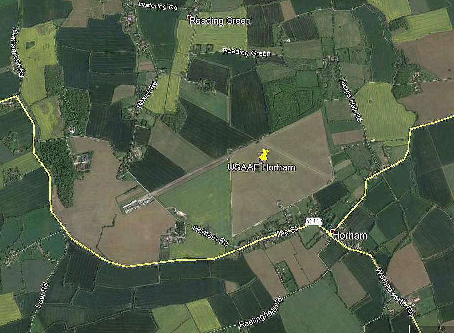
Note: This picture (2017) was obtained from Google Earth ©
The layout of the WW2 runways can be clearly discerned, as can parts of the airfield perimeter.
Military users: WW2: 8th USAAF 13th Bombardment Wing 95th Bomb Group
334, 335, 336 & 412 Sqdns (Boeing B.17 Fortress)
Location: WSW of Stradbrooke & NW of Horham villages, N of B1117, 4nm ESE of Eye
Periods of operation: Military: 1942 to 1963 Private: 1998 to -
Runways: WW2: 07/25 1829x46 hard 01/19 1280x46 hard
13/31 1280x46 hard
A MICHAEL T HOLDER GALLERY
We have Mike Holder, a great friend of this 'Guide', to thank for researching this subject and kindly providing the following items:


Photo One is of the Boeing B-17G Flying Fortress, 43-31057, of the 95th Bomb Group, obtained from the American Air Museum.


Photo Two, of a B-17 Fortress taking off, is from Bombers of WWII by Jeffrey I Erthell. Photo Three of one of the B-17 hangars is from Fortress Down by Douglas L Bockus.


Photo Four is of 1st Lieutenant George Dancisn, Captain of 'Full House' taken in the summer of 1944. Photo Five is of the crew of 'Full House', presumably taken around the same time?


Photo Six is of the crew after a raid on Berlin from The Munster Raid by Ian Hawkins. Photo Seven is of a crew outside the Briefing Room in August 1944 from the American Air Museum, as was Photo Eight.


Photo NIne was published in the East Anglian Daily Times on the 19th September 1981. The area view is from my Google Earth © derived database.
NOTES: At Flying For Fun at KEMBLE in 2006 Mr Andrew Castleden flew in with the Citabria G-BRJV booking-in from HORHAM. Putting two and two together to make five, is there now evidence of an airstrip being established on this WW2 site?
In January 2008 I moved an Auster 4 that had just been brought by Mr Castleden so got the full story. He had obtained planning permission to use part of the 07/25 runway, on the south side, (an area swept and restored of about 470 x 15/20 to operate a Vans RV.9 G-HOXN from. His Citabria had been crashed when used elsewhere for solo rental/training duties.
We'd love to hear from you, so please scroll down to leave a comment!
Leave a comment ...
Copyright (c) UK Airfield Guide
