


Seething
SEETHING: Military aerodrome later civil aerodrome
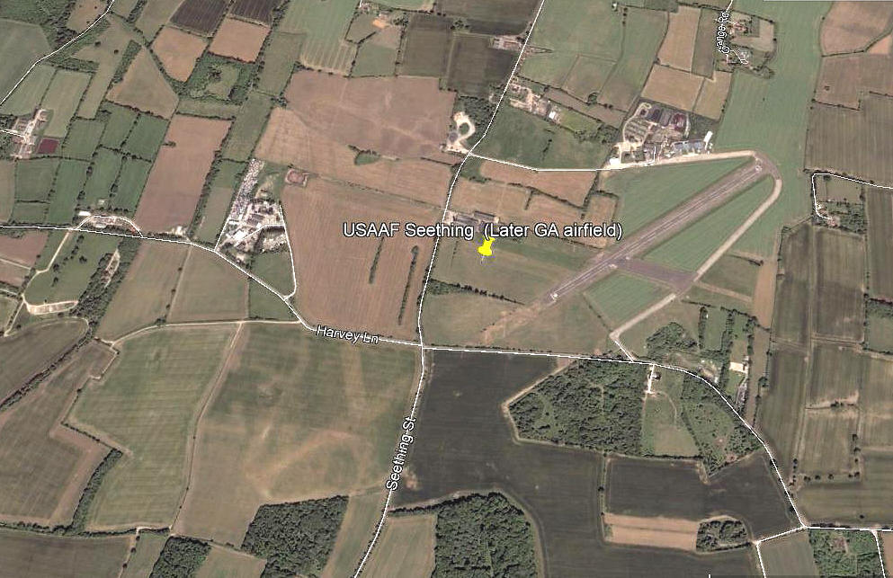

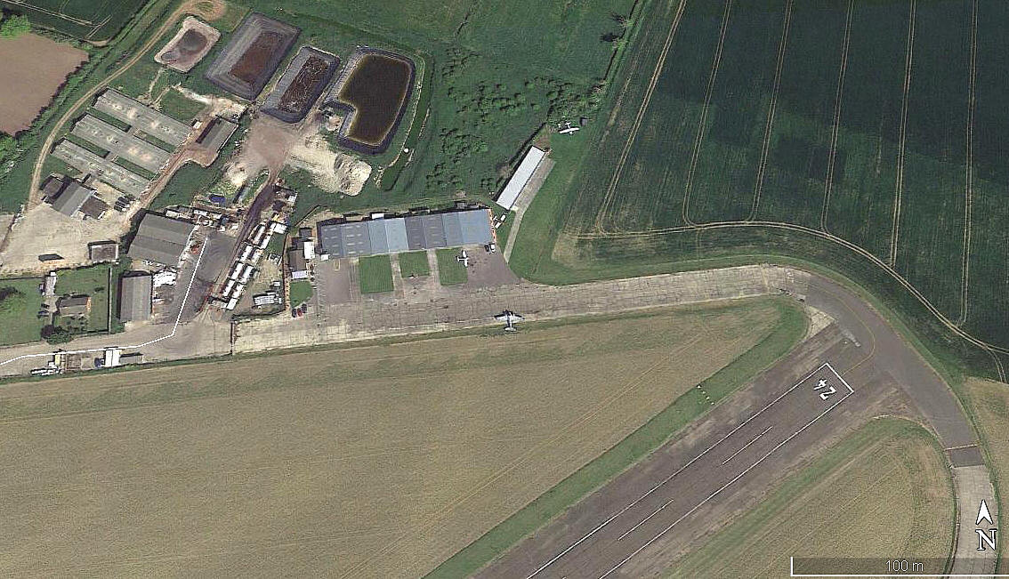
Note: All three of these pictures were obtained from Google Earth ©
The 2011 picture is especially interesting, presumably taken during a very dry period, as it clearly shows the WW2 layout of the runways.
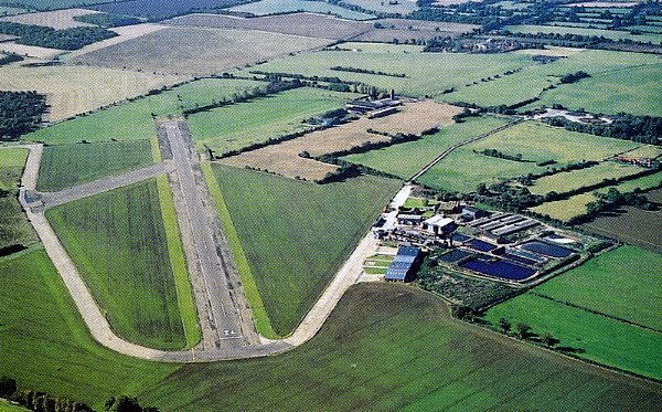
Note. Picture scanned from Todays's Pilot magazine, March 2001.
Military user: WW2: 8th USAAF 20th Bombardment Wing 448th Bomb Group
712, 713, 714 & 715 Sqdns (Consolidated B-24 Liberators)
Note: It appears that a squadron of North American P-51 Mustangs were also based here. Can this be confirmed, and, if correct, which squadron was it?
Operated by: 1960s to 2000: Waveney Flying Group. WFG still here in the 1990s up to 2001 at least .
From 1990 to 2004 (at least) then operated by Wing Task 95 Ltd
Location: In/near & S of Seething, E of the A144 (now the B1322?), WNW of Thwaite St Mary village, about 9nm SE of Norwich
Period of operation: Military 1943 to 1945. Civil from 1960s (?) to -
Notes: The airfield was built by John Laing and Son Ltd between 1942 and 1943 to a Class A standard for heavy bombers with temporary accommodation, albiet of a much higher standard than many RAF Bomber Command had to endure. Basically, when the USAAF arrived they were given the best locations to fly from - East Anglia. RAF Bomber Command, especially for heavy bombers, were shoved up north to Lincolnshire and south Yorkshire were the much poorer weather and regular fog prevailed. The airfield was opened on the 1st December 1943 and the 448th Bombardment Group (Heavy), moved in with their B-24 Liberators.
They flew a wide variety of missions specifically identified as being crucial to ending the war as soon as possible. For example, aircraft factories, ball-bearing plants,chemical and synthetic oil refineries etc. The RAF Bomber Command, under 'Bomber' Harris, were, to a large extent, still area bombing cities. Harris had not learnt that this strategy does not work. And, very recently, the British public had amply demonstrated this, showing incredible fortitude to survive during the 'Blitz'.
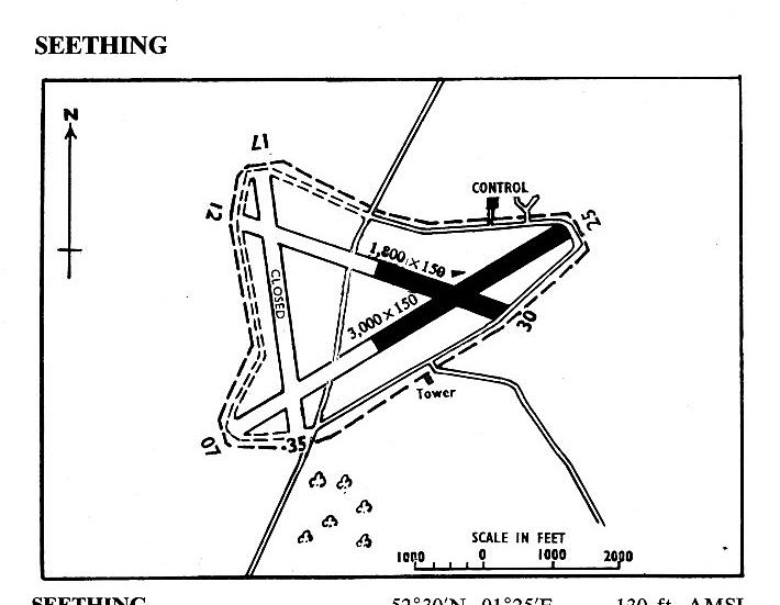
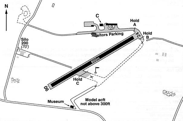
Note: These maps are reproduced with the kind permission of Pooleys Flight Equipment Ltd. Copyright Robert Pooley 2014.
Runways:
WW2: 07/25 1829x46 hard 01/19 1280x46 hard 12/30 1280x46 hard
1965: 07/25 914x46 hard 12/30 549x46 hard
1990: 06/24 874x23 hard
2000: 06/24 800x18 hard
NOTES: Another substantial USAAF bomber base with 2894 personnel on station in late 1944.
A MICHAEL T HOLDER GALLERY
We have Mike Holder, a great friend of this 'Guide', for researching what is available to illustrate this listing and providing extra items.


Photo One from the American Air Museum (AAM), is of the B-24 'TARFU 11 of the 449th Bomb Group - presumably having dverted? Or simply landing at the wrong airfield? Possibly just visiting?
THE B-24 Liberator "Bag O'Bolts:


Photo Six shows Bryson's crew with Col. Westover (far right), before leading the entire 8th Air Force on Mission 24. The entire 8th Air Force? Advice will be most welcome. Photo Seven shows three wrecked B-24s.


The local area and area views are from my Google Earth © derived database.
NOTES: SEETHING today is awash with many light aircraft. Not so in 1976/77 though, In 1976 it seems only four GA aircraft were based here: The Auster J/I Autocrat G-AIPZ , DHC.1 Chipmunk G-AKDN, DH.82A Tiger Moth G-ANJA (N9389) and M.S.892A Rallye Commodore G-AYES of the Waveney Flying Group.
A REVELATION
When I first flew in here in 1993 I was astonished to find a possibly unique, but thoroughly practical and easily moveable, (I think it was powered by an electric motor), circular and almost multi-layered ‘carousel’ type arrangement for storing aircraft in one of the hangars at least. A brilliant idea and I wonder if it has been adopted elsewhere as it seemed to almost guarantee maximum use of space whilst aircraft stayed free from the danger of ‘hangar rash’. The aerodrome was alive with activity and many aircraft were based here.
We'd love to hear from you, so please scroll down to leave a comment!
Leave a comment ...
Copyright (c) UK Airfield Guide
